11.1 Why geolocation is the heart of the rule
Traceability down to the plot is what makes it possible to show that no deforestation occurred at the specific place of production (FAQ 1.1). No product may be placed on the market or exported unless the geolocation has been collected and submitted in the DDS — the only exception being the postal address of an MSPO (FAQ 1.1). There is no exception for low-risk countries (FAQ 1.28).
11.2 Technical rules
| Rule | Content | Source |
|---|---|---|
| Precision | Latitude and longitude with at least six decimal digits. The system pads with zeros where fewer digits are supplied | Article 2, point 28; FAQ 7.17 |
| Point or polygon | Plots of up to 4 ha: a point or a polygon. Above 4 ha (except cattle): a polygon with enough vertices to describe the perimeter | Article 2, point 28; FAQ 1.1 and 1.8 |
| Cattle | One point per establishment, covering all of those where the animal was kept, from birth to slaughter | FAQ 1.1 and 1.8 |
| Circles | Using a centre point plus a radius instead of a polygon is not allowed | FAQ 1.16 |
| One polygon, one plot | Each polygon describes a single plot (contiguous or not); it may not enclose an area that only partly contains plots | FAQ 1.14 |
| Plot size | There is no minimum or maximum; the plot must capture the exact area of production with homogeneous conditions | FAQ 1.7 |
| Format | GeoJSON, WGS-84, EPSG-4326; upload by file or manual entry | FAQ 7.8 and 7.26 |
| File size | Up to 25 MB per statement — more than a million points or vertices | FAQ 1.7 and 7.16 |
| Several countries | Places of production listed separately by country | FAQ 7.13 |
| Collection | Mobile phones, handheld GNSS devices and free GIS apps; a satellite signal is enough, no mobile network needed | FAQ 1.1 |
To keep files small: use points for areas below 4 ha, simplify vertices (a rectangle can be described with seven points instead of 168) and avoid over-declaration (FAQ 7.16).
11.3 Responsibility for accuracy
- The operator may use the geolocation supplied by the producer, but responsibility for its accuracy lies with the operator (FAQ 1.11).
- The operator must verify, and be able to prove, that the geolocation is correct; incorrect information is a breach of its obligations (FAQ 1.12).
- No personal data of farmers is required, only the geolocation of the plot — unless they are direct suppliers or operators (FAQ 1.10).
- The absence of a land register or of title does not prevent geolocation; public or communal land actually used as plots may be designated (FAQ 1.6 and 1.10).
- The operator is responsible for the accuracy of the data whatever intermediary is used to collect it — cooperatives, certifiers, national systems or companies (FAQ 1.10).
11.4 The ban on mass balance, and segregation
Chain-of-custody models based on mass balance, which allow deforestation-free product to be mixed with product of unknown origin or associated with deforestation at any stage, are not permitted (FAQ 1.4; Infographics, Table 8; Guidance, section 10.a). The consequences:
- products destined for the EU must be physically segregated from products of unknown origin or non-compliant products at every stage;
- full identity preservation is not required: compliant products from several known origins may be mixed with one another;
- for bulk commodities such as soy, the operator must identify every plot involved in a consignment and ensure there was no mixing with unknown origin (FAQ 1.3);
- a product is compliant if 100% of the commodities can be traced to the plot, are legal and deforestation-free and were never mixed with unknown origin (FAQ 1.5).
11.5 The silo and continuous processing rule (FAQ 1.17)
Where compliant goods from several places are combined in the same silo, pile, tank or warehouse and only part is placed on the EU market, the declared place of production must include:
- all goods that entered the silo since it was last emptied; or
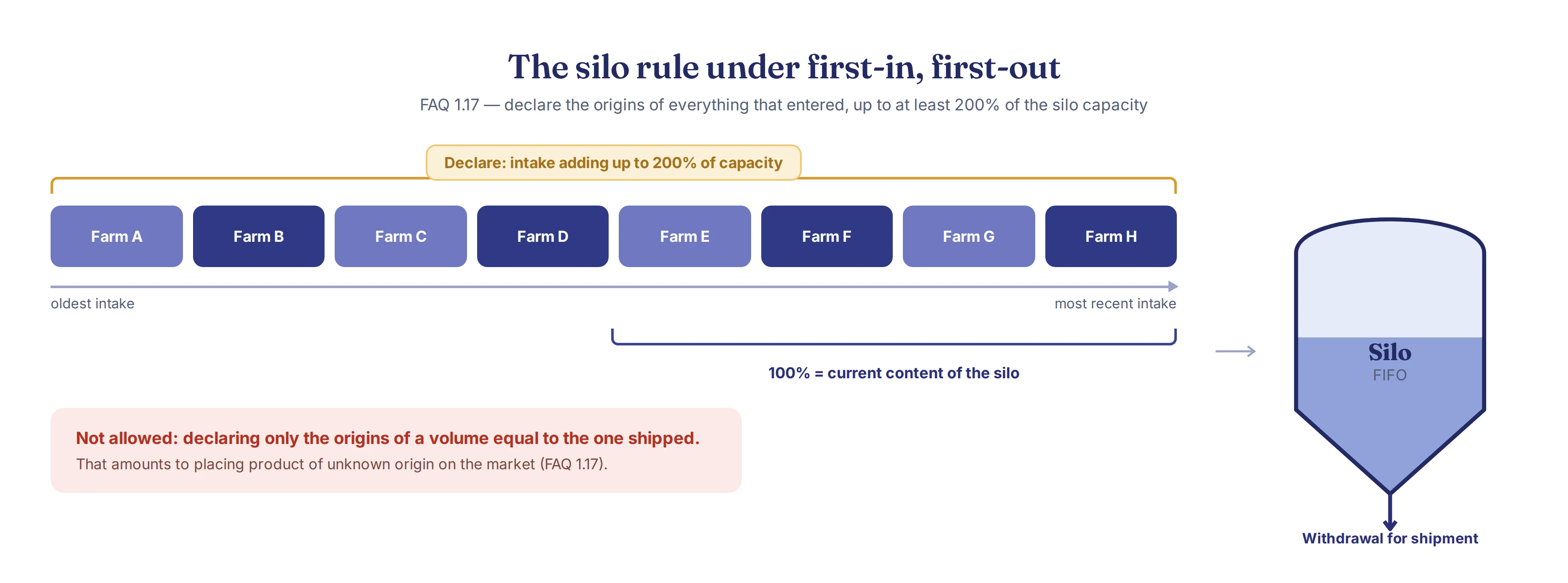
- if the silo is not emptied regularly, all goods that entered over a period that guarantees no mixing with unknown origin. The FAQ recognises as a safe approach declaring the geolocation of everything that entered the silo up to a minimum of 200% of its capacity, provided it operates on a first-in, first-out (FIFO) basis, or an equivalent that guarantees chronological depletion.
The same logic applies to piles, tanks and continuous transformation processes (crushing, for instance). Other approaches are accepted where they guarantee the absence of mixing.
It is not allowed to declare only the origins of a quantity "x" matching the volume shipped, because that would breach the prohibition on placing products of unknown origin on the market.
11.6 Over-declaration — FAQ 1.18
The principle is a strict match between product and plot. Declaring more plots than were actually used is accepted only in specific situations:
- a bulk commodity fully traced to the plot and not mixed with unknown origin, combined in silos, vessels or plants, where only part of the total is placed on the market;
- crop rotation across a set of fields on a farm, where the soy moves from one area to another each year.
The consequences of over-declaring:
- the operator takes on full responsibility for all declared plots, used or not;
- if one declared plot is non-compliant, the whole set is non-compliant;
- it must carry out full due diligence on all of them, with particular attention to the criteria in Article 10(2)(i) and (j), and prove negligible risk for each one.
Over-declaration at regional or national scale is generally not compliant with the Regulation: it would prevent the mitigation of circumvention risk and enforcement by the authorities.
11.7 How authorities and operators verify
Operators (and non-SME downstream operators and traders) and authorities can cross-check the coordinates against satellite imagery and forest cover maps (FAQ 1.19). The analysis is retrospective: it checks whether the cultivated area was forest as from 31/12/2020 (FAQ 5.12). The Regulation prescribes neither a tool nor a minimum image resolution (FAQ 5.18).
Authorities may use Earth observation data (Copernicus), anatomical, chemical or DNA analysis and field audits, including in third countries with their agreement (Article 18(2); FAQ 1.21).